Iowa maps
Top Contributors..
Claim the World, Map by Map
Claim a country by adding the most maps.Celebrate your territory with a Leader’s Boast.
Become World Leader by claiming the most!
Iowa Cities by Map Count..
- 3Moline maps
- 2Boone maps
- 2Des Moines maps
- 2Farmington maps
- 2Maxwell maps
- 1Anamosa map
- 1Ankeny map
- 1Bagley map
- 1Baldwin map
- 1Bedford map
- 1Belle Plaine map
- 1Brighton map
- 1Cassville map
- 1Chariton map
- 1Creston map
- 1Danville map
- 1Davis City map
- 1Drakesville map
- 1Duncombe map
- 1Durango map
- 1Eldora map
- 1Estherville map
- 1Farley map
- 1Fayette map
- 1Forest City map
- 1Hamburg map
- 1Hampton map
- 1Indianola map
- 1Iowa City map
- 1Kellogg map
- 1Keosauqua map
- 1Lake View map
- 1Le Mars map
- 1Marion map
- 1McGregor map
- 1Melbourne map
- 1Miles map
- 1Montezuma map
- 1Northwood map
- 1Oskaloosa map
- 1Polk City map
- 1Rathbun map
- 1Shellsburg map
- 1Solon map
- 1Stanton map
- 1Strawberry Point map
- 1Waterloo map
- 1Waverly map
- 1West Liberty map
Related Info
Iowa Keywords
Iowa Maps

Pikes Peak State Park Map
Map of trails, effigy mounds and park facilities in Pikes Peak State Park.

Pilot Knob State Park Map
Map of trails and park facilities in Pilot Knob State Park.

Prairie Rose State Park Map
Map of trails, lake depths, fishing spots and park facilities in Prairie Rose State Park.

Quad Cities Area, Illinois Map
Tourist map of the Quad Cities Area, Illinois. Shows lodging as well as museums, golf courses...

Red Haw State Park Map
Map of trails, lake depths, fishing spots and park facilities in Red Haw State Park.

Rock Creek State Park Map
Map of trails, hunting and fishing areas in Rock Creek State Park.

Seven Oaks Recreation Area Ski Trail Map
Trail map from Seven Oaks Recreation Area.

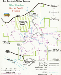
Shimek State Forest Horse Trail Map
Map of Horse Trail Sytem within Shimek State Forest.

Springbrook State Park Map
Map of trails, hunting and fishing areas, and park facilities in Springbrook State Park.

University of Iowa Map
Campus Map of the University of Iowa. All buildings shown.

Viking Lake State Park Map
Map of trails, lake depths, fishing spots and park facilities in Viking Lake State Park.

Volga River State Recreation Area Map
Map of trails and park facilities in Volga River State Recreation Area.
Wapsipinicon State Park Map
Map of trails, hunting areas and park facilities in Wapsipinicon State Park.

Warren County Memorial Park Map

Waubonsie State Park Map
Map of trails and park facilities in Waubonsie State Park.


 Maps contributed
 Big Map
  Gallery


