Edit this map

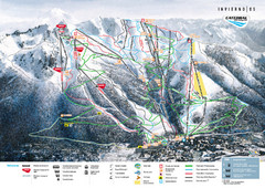
San Carlos de Bariloche Area Tourist Map

near San Carlos de Bariloche, Argentina

View LocationView Map

-41.1212628555768 -71.3768005371094 11 satellite
Nearest Map »  Fullsize
2780 × 1320463 KBJPG

Tourist map of San Carlos de Bariloche, Argentina area in Patagonia on Lake Nahuel Huapi.

From barilochepatagonia.info

federico added
Nov 18, 2008

Rating
rated 4.5 by 2 people

See an error? Report it.

Keywords

tourism, park, lake, torres, del, paine, np

0 Comments

New comments have been temporarily disabled.
See more

Nearby Maps

Bariloche Center Tourist Map

Bariloche Center Tourist Map

Tourist map of town center

4 miles away

Near Bariloche, Argentina
Keywords: tourism, center, city, town
San Carlos de Bariloche Tourist Map

San Carlos de Bariloche Tourist Map

Tourist street map of city

4 miles away

rated 4 by 1 person
Near San Carlos de Bariloche, Rio Negro, Argentina
El Condor Tourist Map

El Condor Tourist Map

Tourist street map

5 miles away

Near El Condor, Rio Negro, Argentina
Catedral Alta Patagonia Ski Trail Map

Catedral Alta Patagonia Ski Trail Map

Ski trail map of Catedral Alta Patagonia near Bariloche, Argentina

6 miles away

rated 5 by 1 person
Near Bariloche, Argentina
Bariloche Trail Map

Bariloche Trail Map

Ski trail map

8 miles away

Near Nahuel Huapi Lake, Bariloche, Argentina
Keywords: recreation
Nahuel Huapi National Park Map

Nahuel Huapi National Park Map

Park map with detail of trails and recreation zones

11 miles away

rated 4 by 1 person
Near parque nacional Nahuel Huapi, Neuquen, Argentina
Keywords: recreation, trails, park
See more