Edit this map

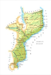
Mozambique Road Map

near Mozambique

View LocationView Map

-18.665695 35.529562 5 satellite
Nearest Map »  Fullsize
1537 × 2241598 KBJPG

Shows major roads. Color-coded by elevation.

Created 3/1970 by M. O. Collins
From www.greatnorthroad.org

Added on
Mar 14, 2009

Rating
no ratings

See an error? Report it.

Keywords

reference, country, road, elevation, africa

0 Comments

New comments have been temporarily disabled.
See more

Nearby Maps

Mozambique Political Map

Mozambique Political Map

0 miles away

Near mozambique
Keywords: reference
Mozambique Map

Mozambique Map

62 miles away

Near mozambique
Keywords: reference
Mozambique National Parks Map

Mozambique National Parks Map

69 miles away

Near mozambique
Keywords: reference
Harare City Tourist Map

Harare City Tourist Map

Map of city center with detail of street names and hotels

300 miles away

Near Harare, Zimbabwe
Lilongwe City Map

Lilongwe City Map

City map of capital

344 miles away

Near Lilongwe, Malawi
Keywords: reference, city, town
South Rhodesia Population Map

South Rhodesia Population Map

This map marks the distribution of population within South Rhodesia.

362 miles away

Near South Rhodesia
See more