Geode State Park Map
near danville, IA
See more


 See more
Nearby Maps

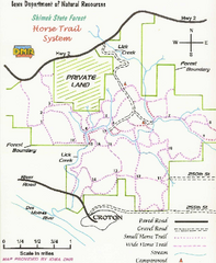
Shimek State Forest Horse Trail Map
Map of Horse Trail Sytem within Shimek State Forest.
21 miles away
Near Croton, IA

Shimek State Forest Hiking Trail Map
Map of hiking trails in Shimek State Forest.
21 miles away
Near Croton, IA

Henderson County Wildlife Area, Illinois Site Map
23 miles away
Near Henderson County, Illinois

Lacey-Keosauqua State Park Map
Map of trails, indian mounds, lake depths and park facilities for Lacey-Keosauqua State Park.
31 miles away
Near Keosauqua, IA

Lake Darling State Park Map
Map of hiking, biking and skiing trails, lake depths and park facilities for Lake Darling State...
37 miles away
Near brighton, IA

Western Illinois University Tranist Map
Map of Western Illinois University transit map throughout campus and Macomb
44 miles away
Near 1 University Cir, Macomb, IL

 click for
 Fullsize

0 Comments
New comments have been temporarily disabled.